Measuring wave height accurately is crucial for various reasons, from assessing surfing conditions to understanding ocean dynamics. Below are the five methods we’ll delve into:
- Oceanographic Buoys
- Satellites
- Marine Sensors
- Bascom’s Scientific Method
- Hawaiian Method
Let’s explore each of these methods in detail, shedding light on their principles and applications. Keep in mind that the data and pricing information provided in this article are based on December 2023 and may vary at the time you read it. For more in-depth information on measuring wave height, visit our website, “How to Measure.”
Oceanographic Buoys
Unveiling the Power of Wave Measurement
Oceanographic buoys represent a cornerstone in the realm of wave height measurement. These sophisticated instruments are designed to capture the essence of ocean waves with precision and accuracy, making them an invaluable tool for oceanographers and researchers. Let’s delve deeper into how oceanographic buoys work and why they are considered one of the most prevalent methods for measuring wave height.
The Anatomy of Oceanographic Buoys
Oceanographic buoys are engineered with meticulous attention to detail. They are equipped with specialized sensors, including accelerometers, which are the key to their wave measurement capabilities. These accelerometers are strategically placed within the buoy, allowing them to monitor motion in three dimensions: side to side, up and down, and front to back.
The Dance of Oceanographic Buoys
As these buoys float on the ocean’s surface, they become part of a delicate dance with the waves. When a wave approaches, the buoy’s accelerometers spring into action, meticulously tracking the buoy’s movements in response to the wave’s energy. This dance is incredibly intricate, with the buoy responding to each wave’s unique characteristics, including height, frequency, and amplitude.
The Precise Determination of Wave Height
The accelerometers’ data is the heart and soul of wave height measurement. By analyzing the buoy’s movements, oceanographers can precisely determine the wave’s height. This process allows for the collection of valuable data about wave conditions, including significant wave height, wave period, and wave direction.
Significant Wave Height: This metric represents the average height of the highest one-third of the waves in a given wave spectrum. It provides a valuable insight into the wave conditions at a specific location.
Wave Period: Wave period refers to the time interval between successive waves. It helps researchers understand the rhythm of the waves and their potential impact.
Wave Direction: By analyzing the buoy’s response to waves from different directions, oceanographers can deduce the wave’s incoming direction, which is crucial for various applications, including navigation and coastal engineering.

Satellites Unveiling the Global Perspective on Wave Height Measurement
Satellites, those celestial sentinels orbiting high above the Earth, have a pivotal role to play in our quest to understand and measure wave height on a global scale. They bring us a perspective that was once impossible to achieve, revolutionizing the way we gather data on ocean waves. Let’s delve into the world of satellite-based wave measurement and explore why it’s such a game-changer.
The Satellite’s Watchful Eye
Imagine a technology that can peer down from space and capture the intricate details of ocean waves thousands of miles away. This is precisely what satellites do. They serve as our eyes in the sky, equipped with advanced radar systems that are specially designed for wave height measurement.
Radar Signals
The Science Behind the Magic
Satellite-based wave height measurement relies on the transmission of radar signals. These signals are directed towards the Earth’s surface, specifically targeting the ocean’s vast expanse. When these radar signals interact with the ocean, something remarkable happens. They generate reflections, bouncing back towards the satellite.
Decoding the Reflections
The reflections of radar signals are not mere echoes; they carry invaluable information about the state of the ocean’s surface. Satellite sensors are finely tuned to capture these reflections and translate them into meaningful data about wave height. This process is carried out with exceptional precision and speed, enabling satellites to collect vast amounts of data in a short span of time.
A Global Perspective
One of the most remarkable aspects of satellite-based wave height measurement is its global reach. Satellites orbiting the Earth provide us with a comprehensive view of wave conditions across the world’s oceans. Whether it’s the waves crashing off the coast of California, the swells in the South Pacific, or the surges in the North Atlantic, satellites can observe and analyze it all.
Marine Sensors
Exploring the Depths
Wave Height Measurement with Marine Sensors
Beneath the surface of the ocean lies a realm of mystery and wonder, and it’s also a place where we find valuable tools for measuring wave height: marine sensors. These sophisticated devices, positioned on the seabed, open a window into the dynamic world of ocean waves. Let’s dive into the depths and unravel the science behind this method of wave height measurement.
The Silent Observers of the Seabed
Marine sensors are like sentinels of the deep, quietly stationed on the ocean floor. They are equipped with the ability to register subtle changes in water pressure, a key indicator of wave height variations. As waves pass overhead, the sensors detect shifts in pressure, and from these fluctuations, they derive precise data about wave height.
Pressure and Height
The Connection
The science behind marine sensors is elegantly simple. When waves rise and fall, they displace water, causing variations in water pressure. This means that as a wave approaches and passes over a marine sensor, it exerts force on the water column above it, leading to an increase in pressure. As the wave moves away, pressure subsides. By measuring these pressure changes, the marine sensor can deduce the height of the passing wave.
Bascom’s Scientific Method
Bascom’s Scientific Method Precision in Wave Height Measurement
In the realm of wave height measurement, precision and accuracy are paramount. Developed by the pioneering oceanographer Willard Newell Bascom, Bascom’s Scientific Method stands as a testament to the marriage of physics and mathematics in deciphering the mysteries of ocean waves. This method offers a reliable and scientifically grounded approach to measuring wave height, and its impact on oceanography cannot be overstated.
A Foundation in Physics and Mathematics
Bascom’s Scientific Method is firmly rooted in the principles of physics and mathematics. It recognizes that waves possess distinct characteristics that can be quantified. Central to this method is the concept of measuring the vertical distance between a wave’s crest—the highest point of the wave—and the mean sea level, as observed from the vantage point of the shore.
The Mean Sea Level Reference
In this method, the mean sea level serves as a critical reference point. It represents the average level of the sea’s surface over time, providing a stable baseline for wave height measurement. By measuring from this consistent reference point to the wave’s crest, researchers can accurately determine the wave’s height.
Reliable and Scientific Data
One of the defining features of Bascom’s Scientific Method is its commitment to providing reliable and scientifically valid data. This method ensures that wave height measurements are consistent, repeatable, and grounded in fundamental principles. This reliability is particularly crucial in the field of oceanography, where precision is essential for understanding complex marine phenomena.
Hawaiian Method
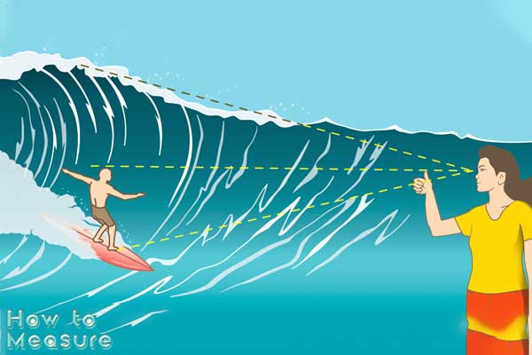
The Hawaiian Method Surfing’s Approximation of Wave Height
In the sun-kissed waters of Hawaii, where surfing is not just a sport but a way of life, surfers have developed their own distinctive method for estimating wave height. Known as the Hawaiian Method, this approach offers a unique take on measuring waves. While it provides surfers with a quick way to gauge wave size, it’s essential to understand that the Hawaiian Method is an approximation, lacking the precision of scientific techniques.
An Art Honed by Experience
For Hawaiian surfers, estimating wave height is an art honed by years of experience riding the island’s legendary waves. Rather than relying on scientific instruments or complex calculations, they employ a straightforward and visual approach. To gauge a wave’s height, surfers focus on its backside, the less dramatic and often overlooked part of the wave.
Dividing by Two
The Hawaiian Rule of Thumb
Once surfers have assessed a wave’s backside, they use a simple rule of thumb—they divide the estimated height by two. This quick mental calculation provides them with an approximation of the wave’s size. For example, if a surfer judges the backside of a wave to be around six feet, they would consider it to be approximately three feet in height according to the Hawaiian Method.
Practicality in the Surfing World
The Hawaiian Method has practical implications in the world of surfing. Surfers need to make quick decisions about which waves to ride, taking into account their size and difficulty level. This method offers a rapid and reasonably accurate way to assess waves and determine if they are suitable for a particular surfer’s skill level.
Limitations and Approximation
While the Hawaiian Method provides a convenient way for surfers to estimate wave height, it comes with inherent limitations. It is, by nature, an approximation and lacks the precision of scientific approaches used in oceanography. Variability in surfers’ judgment and individual interpretations of wave size can lead to discrepancies in reported wave heights.
The Role of Experience
Experience plays a pivotal role in the effectiveness of the Hawaiian Method. Seasoned Hawaiian surfers, who have spent countless hours in the water, tend to have a more accurate eye for wave height estimation. Novice surfers or those unfamiliar with Hawaiian waves may struggle to make precise judgments using this method.
Wave Dynamics
Understanding wave height goes beyond measurement methods. Ocean waves are dynamic and influenced by factors such as distance from the coast, water depth, and seabed bathymetry. Wave size is also affected by the wave period, which refers to the time interval between successive waves.
Conclusion
Measuring wave height is essential for a variety of applications, from ensuring surfer safety to advancing our understanding of oceanic processes. While multiple methods exist, scientific approaches like Bascom’s method provide the most reliable and accurate results. whether you’re a professional oceanographer or an enthusiastic surfer, knowing how to measure wave height enhances your ability to assess ocean conditions and make informed decisions. Waves are ever-changing and complex phenomena, and measuring them is a scientific art that continues to evolve. Explore our website, “How to Measure,” for more insights into the world of measurement techniques.